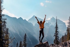
Laguna de la Caldera, 3.020m
download with map as pdf-file >> 
|
|
...more tours in the Sierra Nevada:
- Pico de Veleta |

|
The way from the Information Center at Hoya del Portillo takes you through all the vegetation zones of the Sierra Nevada: forests, green meadows and of course snow & rocks. The way is panoramique in itself and always easy to walk, except from the snow fields above 2.800m. In general, the southern side of the Sierra has a lot more snow and is "greener" than the dry north, as all the rain from the sea comes down here. The walk to the Laguna is one of the best walks in the area, promise!
Photo: The road towards the Laguna with Mulhacen in the background
|
 |
Rating: +++++ |
ascent: 900m |
Start: Hoya del Portillo (2.150m), above Capileira. |
Destination: Laguna de la Caldera, 3.020m |
| Difficulty: low |
Hiking |
descent: 900m |
End: Hoya del Portillo (2.150m), above Capileira
|
Walking Time: Ascent 4h, descent 2,5h. |
Directions: |
Follow simply the road from the Hoya towards Mulhacen
Base: none
Marking: none, and it isn't required.
Information Flyer of the National Park Administration
|
Maps: |
e.g. the Map of the Sierra Nevada National Park, 1:50.000 (available at the tourist information)
Map of the tour (1:50.000) 28k
|
Travel Season: |
June till October
|
Notes: |
From the Laguna experienced hikers can try to climb Mulhacen (I-II), although the easier access is by far from the south via the trail starting from the road. For those who want to walk more, the walk can be extended to the Veleta and finally Prado Llano. Those who want to walk less can take the little coach bus from Hoya del Portillo to Alto del Chorillo (2.722m), which will save you from ascending almost 600 m (=approx. 1,5h), especially for the descent this option is very attractive :-) Ask at the information center for the schedule.
Links: ./.
|